Folia faunistica Slovaca 21 (3) 2016: 251–255
Nikola Ďurišová & Eduard Stloukal
Department of Zoology, Faculty of Natural Sciences, Comenius University, Mlynská dolina B–1, SK – 842 15 Bratislava, Slovakia [stloukal@fns.uniba.sk]
Abstract: Within research of Malacostraca (Crustacea) at the Turčianska kotlina, Slovakia, unusual occurrence of Gammarus leopoliensis Jazdzewski et Konopacka 1989 was reported at five sites. Nearest known sites of occurrence in Slovakia are in different orographic units hundreds kilometres away. Species is mostly know from Southern Carpathians and occurs in Romania, Hungary, Ukraine, Poland and Slovakia.
Key words: Gammarus leopoliensis, Amphipoda, Turiec, Slovakia, distribution.
Introduction
Gammarid species are common inhabitants of European freshwater and more than 100 species have been recorded from Central Europe (Karaman & Pinkster 1977).
Type material of Gammarus leopoliensis Jazdzewski et Konopacka 1989 was collected from Ukraine and Poland (Jazdzewski & Konopacka 1989; Grabowski & Mamos 2011). Except of these localities, species is known from Slovakia (Brtek 2001), Romania (Papp et al. 2008) and Hungary (Papp & Kontschán 2011).
According to Copilaș-Ciocianu et al. (2014), G. leopoliensis does inhabit altitudes between 600–1200 m while G. fossarum does occur water from lowlands to altitude cca 850 m. G. balcanicus can be found in much wider span – from lowlands up to 1600 m.
G. leopoliensis was described based on revision of G. kischineffensis Schellenberg, 1937 by Jazdzewski & Konopacka 1989. For Slovakia, Necpálová (2013) listed its known occurrence in area of the Beskydské predhorie and the Bukovské vrchy mountains and Brtek (2001) reported this species at southern area of Slovakia near to the border with Hungary.
Material and Methods
Sampling
Specimens were collected during year 2015 by standard methods used for sampling of the benthic crustaceans. The samples were stored in 75% ethanol and deposited in the Department of Zoology, Comenius University, Bratislava, Slovakia.
Sampling sites
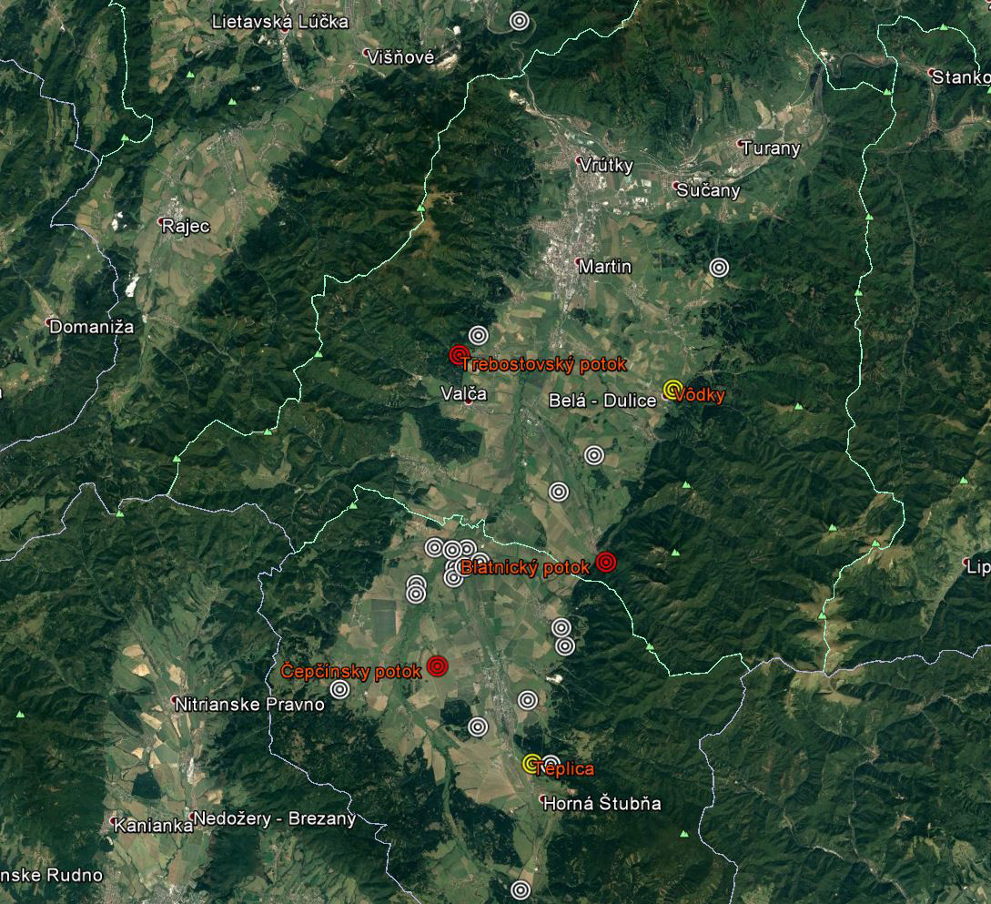
All sampling sites are situated in the orographic unit of the Turčianska kotlina basin, Slovakia (figure 1)
1. Teplica
48°50’17” N, 18°52’45” E, altitude 550 m, 14. 9. 2015
Sampling site nearby the road bridge, banks are not stabilised, covered by dense forest vegetation. Water temperature 12 ̊C, average stream width 4 m, average stream depth 50 cm, vegetation shading 80 %. Bottom substrate – gravel and stones. Meanders with fast stream, no pollution.
2. Vôdky
49°0’20” N, 18°59’4” E, altitude 522 m, 15. 8. 2015.
Site is situated at outskirts of the Belá – Dulice vilalage, nearby the main road. Water temperature was 17 ̊C, average width of stream 2.75 m, water was shallow, almost dried out, water depht at the site was up to 5 cm only. Shading by vegetation (willows and orchard trees) estimation 90 %. Bottom substrate – stones and mud.
3. Trebostovský potok
49°1’27” N, 18°50’14” E, altitude 544 m, 23. 8. 2015.
Site situated at outskirts of the Trebostovo village, nearby cottages and mixed deciduous forest. Stream of uninfluenced character. Water temperature 12 ̊C, average stream width 1.85 m, fast stream, average water depth 45 cm. Vegetation shading 90 % (Alnus sp. and tall grass on banks). Bottom substrate – gravel and stones (over 15 cm).
4. Blatnický potok
48°55’42” N, 18°56’3” E, altitude 534 m, 19. 9. 2015
Site nearby the Blatnica village, the National park Veľká Fatra. Water temperature 10 ̊C, average stream width 1.50 m, average depth of water 30 cm, no vegetation shading. Bottom substrate – gravel and stones.
5. Čepčínsky potok
48°52’60” N, 18°48’56” E, altitude 480 m, 13. 8. 2015
Site nearby field road above the Veľký Čepčín village, among fields. Water temperature 17 ̊C, average stream width 0.80 m, average water depth 12.5 cm only, vegetation shading about 50 % (grasses on banks). Bottom substrate – mus and sand. no stones in stream.
Documentation and identification
Identification to species level was done according to the original species description by Jazdzewski & Konopacka (1989) and by help pf the identification key compiled by Necpálová (2013).
Light microscopy examination was done under Carl Zeiss stereomicroscope and Leica DMD-108 digital microscope. Samples are deposited at the Department of Zoology, Comenius University.
Results and discussion
Altogether five new sites of occurrence of Gammarus leopoliensis at the Turčianska kotlina basin (between mountain ridges of the Veľká Fatra Mts and the Martinské hole Mts), Slovakia. There is not known occurrence of this species in this or adjacent orographic units.
G. leopoliensis was identified based on exopodited of the uropod III exopodites, where both furcated and simple bristles were observed (Figure 4). On the base of the uropod III were no bristles, but few spines only, which appeared also at other parts of uropod III. Lobae of telson have two apical spines, with mostly the single seta located nearby and one or more spines and/or bristles on the distal side of telson (Figure 3).
General habitus of G. leopoliensis is shown at Figure 2.
Ďurišová N & Stloukal E, 2016: Occurrence of Gammarus leopoliensis (Amphipoda) at the Turčianska kotlina, Slovakia. Folia faunistica Slovaca, 21 (3): –255.
[in English]
Received 5 December 2016 ~ Accepted 20 December 2016 ~ Published 29 December 2016
© Faunima, Bratislava, 2016
e–ISSN 1336–4529 ISSN 1335–7522
|
Site name |
GPS coordinates |
DFS Map square |
Species |
|
Čepčínsky potok |
48°52’60” N, 18°48’56” E |
G. leopoliensis |
|
|
Vôdky |
49°0’20” N, 18°59’4” E |
G. leopoliensis; G. balcanicus |
|
|
Trebostovský potok |
49° 1’27” N, 18°50’14” E |
G. leopoliensis |
|
|
Teplica |
48°50’17” N, 18°52’45” E |
G. balcanicus; G. leopoliensis |
|
|
Blatnický potok |
48°55’42” N, 18°56’3” E |
G. leopoliensis |
Table 1. Localities of the Gammarus leopoliensis occurrence.
Figure 1. Map of Gammarus leopoliensis and G. balcanicus occurrence at the Turčianska kotlina basin.
Red circles – G. leopoliensis; white circles – G. balcanicus; yellow circles – both species.
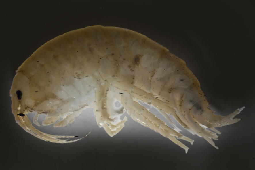
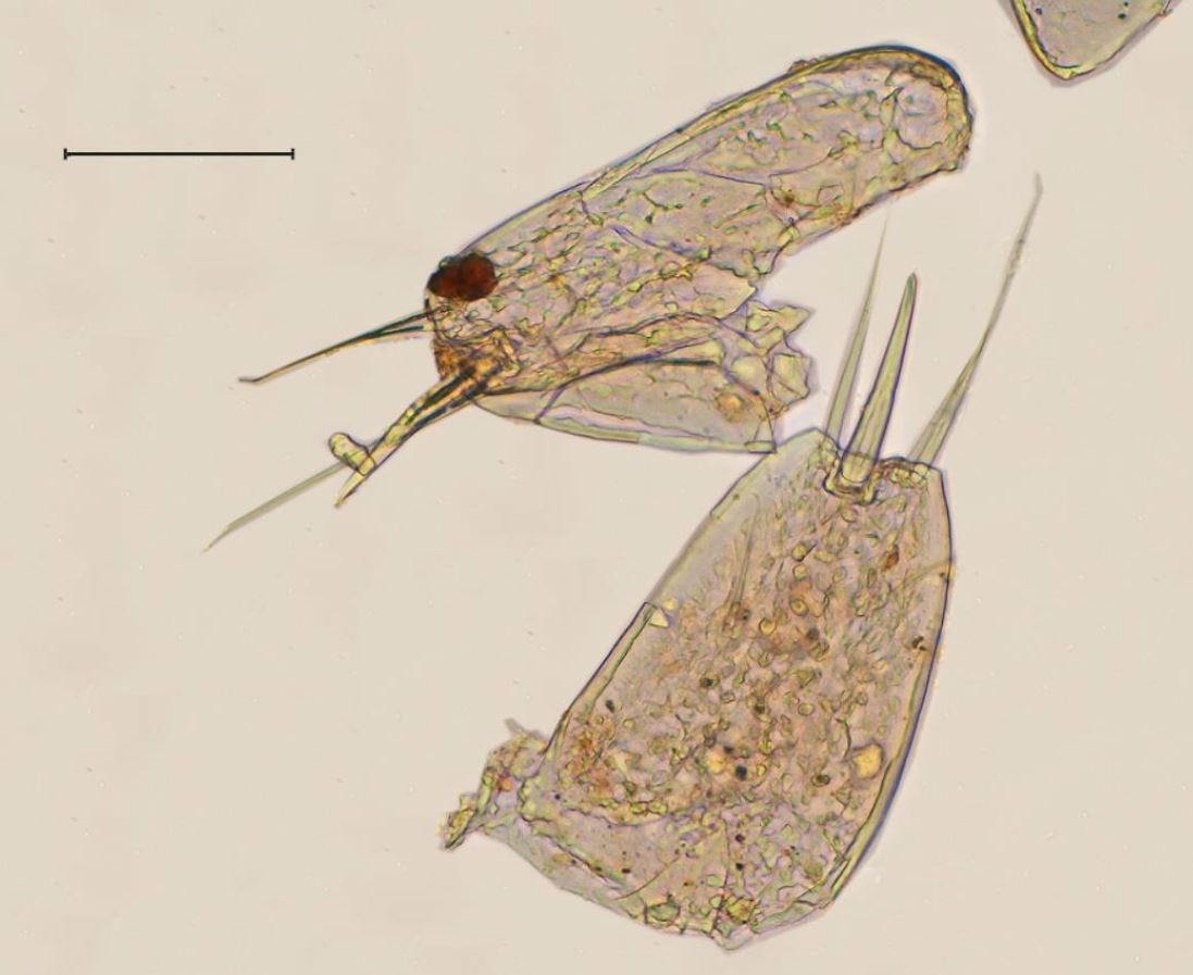
Figure 2. Gammarus leopoliensis.
Figure 3. Telson of G. leopoliensis (scale 1000 μm).
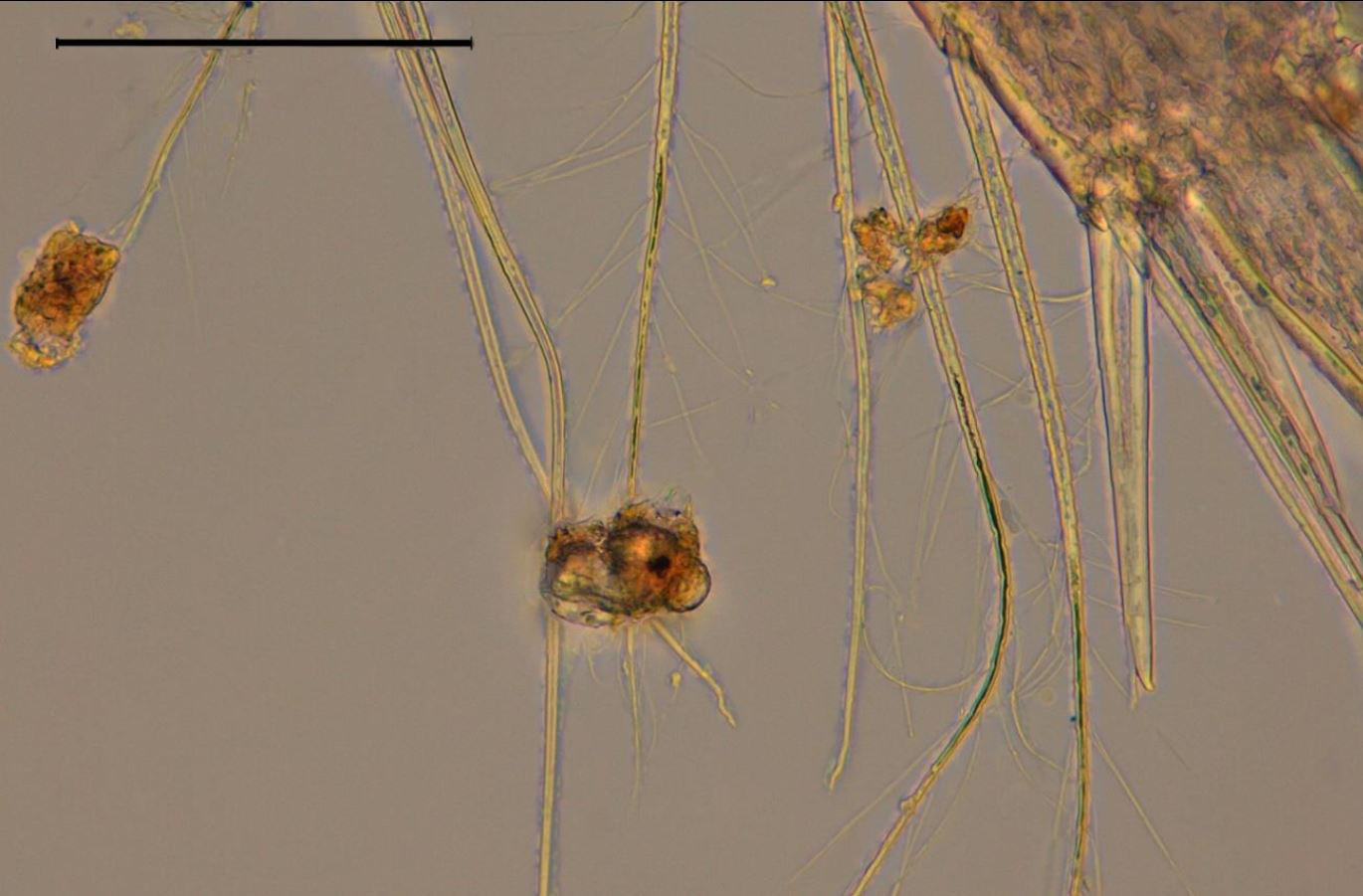
Figure 4. Detail of seta on uropode III of G. leopoliensis (scale 100 μm).
Figure 5. Recent map of know distribution of Gammarus leopoliensis.